Last Update: LATEST RELEASE
VERSION 4.0
Last Update:

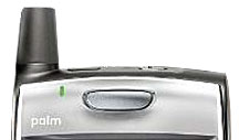
PathAway includes support for expandable Hi-res
screens for OS5 devices like the Garmin iQUE, Tungsten
T|X, LifeDrive, and Sony NR series.
|
|
|
PathAway is the all-purpose software for GPS.
PathAway provides affordable navigational support for aviation,
boating, geocaching, hiking, cycling, touring, rally racing,
automobile (on and off-road), motorcycle touring, ballooning,
fishing, hunting, paragliding, mountain climbing, ultra-light
flying, canoeing, snowmobiling, athletic training, outdoor
education, scuba diving, mapping/GIS, mining, military training,
surveying, site inspection, telematics, field data collection,
security, search and rescue or any application where location
is important.
If you get out and go places, PathAway is the companion
to take with you.
GPS Navigation
Attach a compatible GPS (Global Positioning System) device
to your Palm, and use PathAway to navigate. PathAway works
with all of the leading GPS handheld devices. PathAway supports
Bluetooth, cabled, sled-based, and SDIO GPS devices. internal
GPS devices such as the Garmin iQue 3600 are also supported.
Maps from Anywhere
Import your own maps using PathAway
Tools, or Desktop Mapping Software such as QuoVadis/Touratech-QV.
Get maps from mapping web sites, CD-ROM, scanned, or digitally
photographed. Maps are highly compressed and can be any size
and resolution that fits within your device memory.
Intelligent Moving Map Display
As you travel, PathAway will center the map on your position.
When you exit the boundary of one map and enter another, PathAway
can be setup to automatically switch to the new map. You can
even have the software set to automatically zoom in to the
map of highest detail when you reach it's boundaries. Great
for when you're entering a destination point that requires
precision detail.
Track Up Navigation:
Automatic or manual Map rotation for travel direction up display.
Map Projections and Datums
PathAway supports the most popular Map Projections and Datums,
for precision location pinpointing.
Coordinate Grids:
Display positions in Latitude/Longitude, UTM, OSGB, Quebec-MTM,
MGA, GGRS87, Swedish Grid, Irish grid, or Israel Grid.
Personal Points of Interest/Waypoints
Capture unlimited points and record detailed names and descriptions.
Attach your own custom icon, picture or sound clip for easy
visual scanning.
Record and Follow your Tracks
Record your track as you travel. Then, follow the recorded
track to find your way home.
Point to Point Routing
Create routes quickly by simply clicking points on a map,
or by choosing from your point database.
Navigation Warnings and Alarms
Proximity detection alerts you to upcoming points along your
route, or when you get close to one of your points. If you're
following a route, PathAway will alert you if you've strayed
off-track, or if your elevation has strayed beyond the level
stored in the route. You can even add your own sound clips
to be used for any of the available alarms.
GPS Sky View and Satellite Data View
Analyse GPS Connection to determine quality of reception.
Compass View
Customizable Large Compass view screens showing Heading,
DIrection to Next Point, next turn, or any other available
navigation data. View multiple Compasses on the screen at
the same time, or a single large compass.
PocketMode Power Save Feature
You can now track via your GPS, and save battery life
at the same time. Once you enter PocketMode, PathAway turns
off the screen (or backlight depending on device), and locks
the keys but continues to record GPS data to your track log.
If you using a Bluetooth GPS, simply connect the GPS, enter
Pocket Mode, and put the handheld in your Pocket! No need
to worry about accidentally hitting keys to issue unwanted
commands. Use the special key sequence (or power button) to
exit Pocket mode and return to the View screen.
Manual And Proximity based Route Point Targeting.
Manual means user must select "Advance Route Point"
before PathAway will target the next point in sequence. Proximity
means you must enter within a proximity of a route point before
the next point will be automatically targeted.
Measure distance between 2 points
Want to know the distance between 2 points on the map? Simply
select Measure... from the Popup menu, and click on the 2
points.
Large size Icon and Text Menu display
Double the size of the icons for better viewing, or enlarge
the text on the menus for arms-length viewing, or easier finger
selection.
Import GPS data from Data Logger NMEA file
Download data logged in your Data Logger GPS, (I.e.. RoyalTek
BlueGPS.) and import the NMEA file directly into PathAway.
Import Data Formats
GPX, LOC, and other formats supported via PathAway PC Conversion
Tools, or directly on your handheld. Great for GeoCache users.
GPS fix acquired and lost alarms
Receive audible alerts when a GPS fix is acquired or lost.
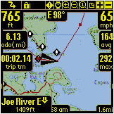
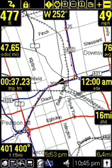
Onscreen Trip Statistics on a Customizable Dashboard
Display the information you need while still having a great
view of the map. Custom 12 edges of the screen to pop-out
to show the info. Stats such as ground speed, average and
max speed, and vertical climbe/descent speed. elevation, geographic
coordinates, directional heading/ ground distance/vertical
distance/vertical angle to next point, turn or destination.
Odometer, elapsed time, Estimated time enroute,
OS-5, Hi-Res and Expandable Screen Support
PathAway runs on the latest Palm OS 5. It includes Hi-Res
support for Palm and Sony devices. In addition, PathAway supports
Expandable screens on Sony and HandEra devices.
Transfer Data To and From Garmin and Magellan GPS
Devices
PathAway works great as a waypoint, track, and route manager
for your Garmin or Magellan handheld GPS. Backup all your
data on the GPS in PathAway. Create Routes using PathAway
and your own maps, then upload the route to the GPS.
Beaming
Share maps, points, routes, and tracks with others, by beaming
directly to their Palm.
Get your maps from mapping web sites, CD-ROM, scanned, or
digitally photographed. Use the free PathAway
Tools for Windows to prepare and manage maps. Maps can
be any size and resolution.
 PathAway
integrates Garmin iQue GPS PathAway
integrates Garmin iQue GPS
PathAway
supports the Garmin iQue internal GPS and expandable screen.
Click HERE for Details.
Download
your free trial now.
PathAway supports Palm OS™
version 3.5 or higher.
|