PathAway GPS 5 - Professional Edition
Windows Mobile


PathAway Professional Edition has all of the features of PathAway GPS 5 - Standard Edition plus new features targeted towards power users and professionals. Of significance, PathAway PRO has 2-way wireless remote location tracking. See where others are right from your handheld, share your location with others, or send to a central tracking service. Also, with PathAway Professional, you don't need to load maps beforehand. You can have them downloaded wirelessly to your handheld, as you navigate.

Web Maps

Web Maps allows you to download maps on-the-fly from a Map Server on the internet. Maps will be downloaded in the background and displayed on the screen as they complete downloading. Maps are cached, so downloading only needs to be done once. See Options->Web Maps Dialog to configure.
Note: WebMaps downloads data from third-party Map Servers so availability of these maps may change at any time without notice. MuskokaTech provides no warranty or support of the quality of these maps.
Maps currently supported:
Google Maps: Worldwide street, satellite, and terrain maps.
Terraserver-USA Maps: USGA Topographic and aeriel photo maps. Covers USA only.
OpenStreetMap.com: User contributed Street Map Community. Covers most of World.

OpenCycleMap.com and OpenTopoMaps.com: User contributed topgraphic and terrain maps. Covers most of World

Vector Maps

PathAway GPS 5 professional has support for unlocked Garmin IMG Vector maps. These maps can be viewed either stand-alone, or as overlays on your raster maps.


Location Sharing and Tracking

Send My Location: (SMS capability or Internet connection required)

Send current GPS location to another user or remote tracking service via SMS or Http protocol. See PathAway Send/Receive Format  document for the supported send formats. Send manually via command, or have location sent automatically based on the following frequency intervals:

  • Automatic Time Interval: Send location at the specified time intervals.
  • Automatic Distance Interval. Send is triggered every x distance traveled.
  • Automatic Distance Interval from Start. Sends your location as you cross the threshold of the specified distance from your start location. If you move back towards your start location, the trigger will again send the location. This feature is very useful for search and rescue purposes where the distance from a start location is needed in order to determine a search radius.
Retrieve Remote Locations (SMS capability or Internet connection required)

As new Remotes are retrieved, they are assigned a default background color for display on the map. This color can be modified by Editing the Remote Item Info. Remotes are tracked by their ID passed along with the location message. The Label for a remote can be modified by the user for easier on-screen identification.

Retrieval is achieved either when an SMS message containing location information is received, or via automatic or manual polling of an Http-based Tracking server.

For Servers that return timestamp information, PathAway will download only updated location information.

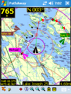
On-Map Remote Labels:

- For each remote location being tracked, the tag on the map can display current location and heading of remotes, course, speed, elevation of remote, date/time of retrieval, distance to, course to, and elevation difference.

Remotes View Screen.
Shows the map and list of Remotes. Remotes are listed showing distance and heading to. Tap and hold on an item to bring up the context menu for commands to issue on the remote item.
Remotes Commands

- Enable Remote Tracking. This will toggle the automatic send/retrieve of locations
- Goto Next Remote, Goto Previous Remote. Centers map on Remote.
- Concept of Active Remote. Active Remote is the current (or last) remote the screen was centered on. Goto Active Remote centers map on this remote.
- Auto Center Remote. This will cycle through all of the enabled remotes.


Advanced Features

Calculate Location by Vector

Calculate a new Location by entering a distance and course from a starting location.
Available from Goto Location and Point Edit Location dialogs. Great for geocaching when you're provided only with a course and distance vector from your current location.

Pace Keeping

You can setup your own navigation and tracking system to monitor your pace based on either a desired average speed, or compared against a previously recorded track. PathAway has dashboard display options show your pace in relation to your target.

Directional Alarms

- In addition to the off-track and altitude warnings, turn instructions, and proximity notifications, PRO now offers different alarm sounds for left and right turns, left and right of off-track warning, and high and low elevation warnings.

Custom Alarms can trigger external programs
- Set the alarm sound in a Point to "EXEC <url or program name>" to have PathAway launch a special program or call up a Web Page when the proximity to the point has been reached. Great for tour guide application.
Find Location by Street Address Lookup: (Internet connectivity required)

Enter a street address, then choose from the closest points found. Choose whether to show the point on the map, add a new point, or navigate to the address location.