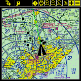
Full Screen Map View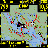
Utilizes full screen to give the largest map viewing area. |
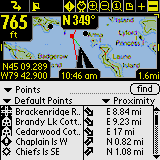
Proximity View
Tells you where Points are from you. Point Icons are shown on
the maps. |
|
|
Tracking View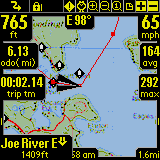
Shows Time, Speed, Distance, information. Blue line on map
indicates recorded track.
|
Route View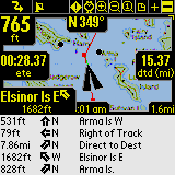
Shows route progress. How close to your route track. Time, distance
and course to next point and destination. Red line indicates
current route. |
|
Point View
Shows items from the points, tracks and route databases. Allows
displaying them on the map or placing them into a route. |
Hide Dashboard Control
Hide the Dashboard for large screen map viewing. |
|
Hide Toolbar

Use Entire screen for widest map viewing |
Customize Dashboard
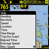
Customizable Dash Options allow you to see the information you
want. |
|
Start New Trip Dialog
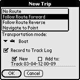
Easy selecting of route and track recording log. |
Onscreen Menus
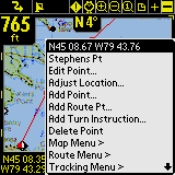
Onscreen context menus provide flexible control for adding
and editing points, creating routes, or positioning maps.
|
|
Route Databases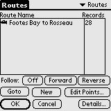
Lists all of your routes. You can create new routes, edit a
route, or choose an existing route to follow forward or reverse. |
Route Details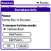
Edit route information such as name, and mode of transportation.
|
|
Recorded Tracks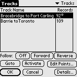
Lists of your recorded tracks. Choose a track to follow for
pin-point accurate routing. |
Download Tracks
Manage your tracks by duplicating or joining tracks, and transfer
between Garmin GPS devices. |
|
Maps 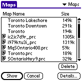
Lists all loaded maps. Choose display to show the map on-screen.
Transfer maps between memory expansion cards. |
Map Details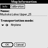
Edit map information such as name, and geographical coordinates. |
|
Map Details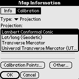
Use Projected maps for precision plotting on wide scale maps |
Map Details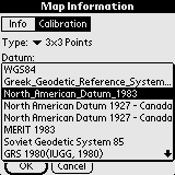
Supports most common map datums. |
|
Map Calibrate Options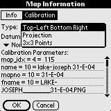
Adjust your map geographical boundaries for pin-point accuracy,
in a number of ways. |
Nudge Map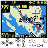
Fine tune your map by nudging it's coordinates in incremental
values.
|
|
Points Database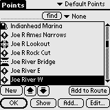
Lists all points. Points may be stored in multiple databases.
Select a point to "Goto" on the map, edit point information,
delete, add new points. |
Point Details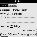
Edit point name, geographic location, description, and choose
an icon to represent the point on the map. |
|
Point Details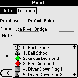
Apply your own custom made icons to your points. |
|
|
Preferences
Tracking
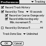
Set track recording preferences. Control how large the track
file can get, and how often data is logged. |
Preferences
Time Estimation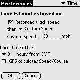
Control how time-based estimates are calculated. Time estimates
can be set to the exact time it took on a followed track. |
|
Preferences
General
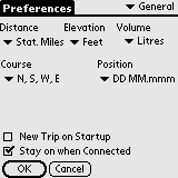
General settings for units of measure. Override handheld's auto
shutoff feature. |
Preferences
Map Display Options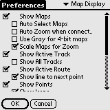
Control what layers are displayed on the maps. |
|
|
Preferences
GPS Configuration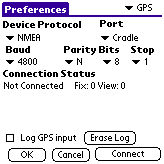
Setup for GPS device. Watch GPS input stream to ensure communication
is working properly.
|
Preferences
Alarms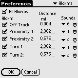
Have audible alarms sound when you reach points of interest,
or get off your route track. |
|
Preferences
Line Style

Change the width and color of Route and Track lines for easier
viewing. |
Preferences
Position Marker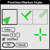
Adjust the size, style, and color of the location postion marker. |
|