 |
|
Welcome to this edition of the PathAway Newsletter.
This is a regular mailing to inform you of recent
news, products, and information for PathAway GPS Navigation
and Mapping software. You are receiving this because
you subscribed on our website at http://pathaway.com.
|
PathAway
GPS 5 for Windows Mobile
*** RELEASED ***
|
|
PathAway GPS 5 Standard
and Professional Editions for Windows Mobile have
been
released! This exciting new version
contains some powerful new features, and a redesigned
User Interface which includes a "Finger Touch" mode
to make interaction with the program easy while on
the move. PathAway 5 is built for Windows Mobile Pocket
PC, Smartphone, Professional, Classic, and Standard.
Click Here to Download and try PathAway GPS 5
Note: This will not overwrite PathAway 4 installations.
Professional Edition $95.00 US
Standard Edition $59.95 US
Upgrade Price: $29.95 US
Here are a few of PathAway 5's new screenshots:
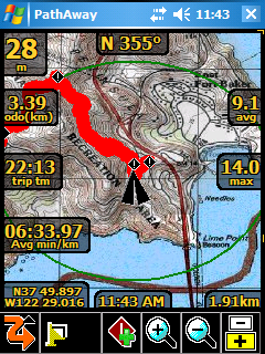 |
Transparent Dashboard
See more of the map, while displaying the stats
you need.
Large Tool Buttons for easy selection while
on the move.
|
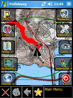 |
Transparent
"Finger Touch" Menus
Large Icon Menus for easy selection by Finger
or stylus while on the move.
Transparent so you still have the full map
view.
Modeless so you can still navigate while making
selections.
Customizable "Favorites" menu for quick access
to your most commonly used commands. Tap and
Hold on a menu item to make it your favorite.
|
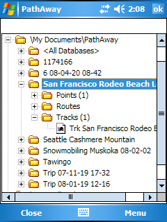 |
Manage Trips
Import GPX files and Retain all information
from Points, Tracks, and Routes. Export
them back out as GPX files for sharing with
others.
Add and Remove data. Add by selection or drag
and drop.
Activate a trip to use for navigation.
All new points, and track logs created while
the trip is active will be added to the
trip.
|
Here's a list of some of the new features include:
PathAway GPS 5 Standard
and Professional
PathAway GPS 5 Standard
and Professional
- New Transparent Dashboard. See
the entire map even with a loaded set of Dashboard
items.
- New "Finger Touch" UI. Uses icon
based drill down menus. Main navigation screen is
always live while the transparent menu options are
displayed. This is to allow the user to choose menu
options while on the move and still see where they
are going.
- Profile View: Elevation and Speed
Profile of current Route.
- Increased performance and better responsiveiness-
Fast screen refresh with background data processing.
No need to wait for screen refreshes.
- Scale Zoom In and Out: More responsive
Zoom In and Out. More zoom increment levels.
- Dashboard; Item Hide/Show now
just hides the item (doesn't remove it completely,
so you can simply "Show" it when you need to)
- Dashboard XXL Font.
- More Dashboard stats like Time/Dist (useful for timing sports and training activities,
ie. 5 min per km).
- Trip Management. Keep your Tracks,
Points and Routes together for a specific Trip.
Especially useful for Importing and Exporting GPX
or KML files. Create Trips, Drag and drop Routes,
Tracks, Point databases into a Trip file.
- Start New Trip Wizard: Step by
step setup of a trip configuration. Select and existing
"Trip" to use or create a new one, choose route
or track to follow, and setup track logging configuration.
- Favorites Options for "Finger
Touch" UI. Can Add any item to Favorites menu.
- Point Info is now Html based. Basic info is implemented
now. Richer formats will be added including imported
html from GPX files.
- More Compressed Maps: Create
8-bit maps using a customized color palette. Now
create highly compressed maps without losing color
quality.
- Track and Route Info showing,
total distance, time, and area.
- Tracks/Routes/Point DB/Maps - Supports
"Multiple Select" for Delete, Move To...
commands.
- "Add Point To Track" and "Add
Turn To Track" added as options for Hard
Keys.
- New Grid Coordinates: MGRS, Swedish
SWEREF99TM, Swiss CHRREF95, CH1903,Warschauer.
- Pocket Mode Preferences options.
Now there is an option to keep the screen on with
the keys locked so you can pull the unit out for
a quick progress check.
- Language selectable from Preferences:
In the Multilingual Installer, all available languages
can be selected from the preferences in the program.
The language option is also displayed on first-time
startup. Included languages are English, German,
Italian, Spanish, French, Czech, Portuguese, Chinese
Simplified and Traditional
- Standard Edition gets some features
previously only available in the Professional Edition:
- Find Address by Internet
Lookup.
- Sync GPS time with device
time.
- Time and Distance Radials.
- Record 3D fixes option for
accurate tracking
PathAway GPS 5 Professional
- Additional Features
- Direct Garmin IMG
(non-routeable) vector map support. Simply place
the IMG file in a PathAway registered folder and
it will display as an overlay on the raster maps.
- WebMaps: Support
for OpenStreetMap.com downloadable
seamless maps.
*** Note: If you
purchased PathAway 4 after May 1st 2008, then the
upgrade to PathAway 5 will be FREE. ***
|
|
About PathAway
|
|
If you work or play in the outdoors, PathAway
is the companion to take with you.
For Outdoor Recreation: PathAway
provides affordable navigational support for aviation,
boating, automobile (on and off-road), hiking, cycling,
touring, rally racing, motorcycle touring, ballooning,
scuba diving, fishing, hunting, paragliding, mountain
climbing, ultra-light flying, canoeing, snowmobiling,
athletic training, outdoor education, geocaching,
and more.
For Professional use: PathAway's
powerful feature set makes it a great tool for mapping/GIS,
mining, military mapping, surveying, site inspection,
personnel training, education, telematics, field data
collection, archaeology, security, search and rescue,
asset management, agronomy, or any application where
location is important.
Standard Edition Key
Features:
- GPS Navigation with most GPS Devices (including
Bluetooth)
- Import your own Maps using PathAway Map Manager
- Intelligent Moving Map Display
- Plan trips by creating point to point routes
- Add Personal Points of Interest/Waypoints with
notes, auto and pictures
- Record and Follow your Tracks
- Track, Multi and single Point-to-Point Routing
- Navigation Warnings and Alarms
- Elevation and Speed Profile View
- Trip Management. Container for Tracks,
Points and Routes.
- Onscreen Trip Statistics on a Customizable Dashboard
- Large Compass Display for position status at a
glance
- Map Projections, Grid, and Datum support
- Import and Export of GPX, LOC and Delimited formats
- Export of Google KML format
- Transfer Data To and From GPS Devices
Professional Edition
Additional Features:
- Send/Receive Locations via SMS or Http protocol.
- Monitor Remote Locations
- Calculate Location by Vector
- Directional Alarms
- Custom Alarms can trigger external programs
- Find Location by Street Address Lookup
- Download WebMaps (Google maps or Terraserver)
on-the-fly
Platforms Supported:
- Windows Mobile 6 - Professional (Pocket PC
Phone)
- Windows Mobile 6 - Classic (Pocket PC)
- Windows Mobile 6 - Standard (Smartphone)
- Windows Mobile 5 - Pocket PC
- Windows Mobile 5 - Smartphone
- Windows Mobile - Pocket PC 2003
- Windows Mobile - Pocket PC 2002 (SE up to PathAway
GPS 4)
- Palm OS 3.5 and higher (SE up to PathAway GPS
4 )
Visit us
at PathAway.com for all the details
|
Thanks for reading
the PathAway Newsletter!
|
|
We hope you appreciate the PathAway Newsletter.
We endeavor to make your experience with PathAway
as rewarding as possible, so if you have any comments,
please don't hesitate to contact us.
Enjoy,
The PathAway Team
|
|
|
|