| |
Hello PathAway registered
users,
The highly anticipated
PathAway GPS Navigation and Mapping software version
3.0 is now ready
for DOWNLOAD! PathAway 3.0 incorporates some incredible new features to enhance your
Palm+GPS experience. PathAway 3 takes advantage of the
latest Palm OS 5 capabilities, and works with all the
most popular GPS devices, from handhelds, to Bluetooth, compact
flash, and snap-on units.
You can now zoom
in and out by scaling maps on the fly. You can
even calibrate maps in their original
projection and datum formats for
pin-point accuracy. UTM and
OSGB positioning readouts are also now
available. Full
Hi-Resolution and Expandable
screen support for Palm OS 5 is also implemented.
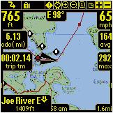
Having trouble reading your route lines at a glance? Now adjust the
thickness and color of all tracks and routes for
easy readability. Even choose different size, color, and style of
current position marker. For routing, PathAway is
even quicker to setup a target point to immediately route to with
Single Point Routing.
Here is the complete list of new features added to version
3.0:
PathAway version 3.0 Features :
* These features highlight only the enhancements made from PathAway
2.1 to 3.0. For a complete description of all of PathAway's features,
please visit us at http://PathAway.com.
|
New Palm OS 5 Support:
Full Palm OS 5 Compatibility. 320x320 Hi-Res Support for
Tungsten etc. Sony 320x480 Expandable Screen
support.
- Requires
at least Palm OS 3.5.
Improved User Interface:
Expanded and Improved Pop-up Context Menus:
Always shows selected position coordinates at top of menu. Quick Map Show/Hide. Add to Route at
Start, to End, or Insert at selected position. Choose Map Layer
by Name and Size (+) or (-).
Quick Point Information screen by selecting Point Name.
- Multiple Points selectable from Points
Menu Pop-up.
Built-in World Map View (Goto Menu). For quick location
re-positioning. New Route on Startup
option.
- New enhancements designed for quick glances
at the screen:
Color and thickness setting for track/route lines. Choice
of 3 different Current Position Pointers, with Color
and Size. Dashboard Color set. Contrast
dashboard to your maps.
Hide Dashboard and Top Toolbar. See the map using the
Entire Screen. Dashboard Text Size
- Small - Normal - Large.
- Auto zoom to Highest detailed map when
connected to GPS.
Cartographer Quality Mapping
Support
Map Datum and Ellipsoid support. Maps can now plot accuraratly
for non-rectangular maps. Map Projection support
in separate Shared Libraries. No need to waste valuable
memory for unused projections.
- Scaling of maps for zoom In and
out.
Expanded Map/Route/Track/Point Database Management:
Visibility of Point/Route/Track Databases switchable on/off.
Added support for Track and Route file support on Cards.
Now all databases may be stored on external cards. Note,
Icon and Vehicle databases stored on cards will make the
application run much slower. Shows Vehicle
and Point Icons on List. Sort by Map Scale. Transportation type
settings for all databases including Points and Maps. Select
the specific Point database to write new Points to. Hide
column data indicator to view long point names.
Icons now shown with Point names.
- Move ALL databases to/from memory
cards.
New Navigation Features:
Single Point Routing. Vertical distance to
next point output. Vertical angle to
next point output. Improved "Position Along Route" algorithm
for more accurate Time and Distance along track estimation.
Improved Route and Track rendering performance by over 800%.
- UTM, OSGB formats added.
GPS Support Enhancements:
Garmin Positioning protocol. No need to switch between NMEA
and Garmin protocols if uploading and downloading your data.
Trackpoints can now be set dependent on the distance traveled.
Garmin Waypoint Symbols. GPS Communications now Interrupt
driven. Preserves batteries for sled-based GPS devices,
and improves program responsiveness.
- Improved "Next Point in Route" detection.
Upload/ Download From GPS:
Track start/stop markers recorded on download of tracks.
- Magellan NMEA data upload/download support.
|
| | |
Touratech-QV and PathAway Continue Software Integration
Touratech-QV Desktop Mapping Software first
integrated PathAway map and data conversion over a year ago. This
latest version of PathAway is even better with support for Projected
maps and datum. Now Touratech maps can be output direct to PathAway
with more precise plotting, and without map distortion. The special
Touratech version of PathAway
will be available soon
in English, German
and French languages. Details at http://PathAway.com/ttqv.htm
PathAway Usage Today
PathAway is being used for tracking race routes
prior to the rally races, hikers download trail maps from the
Internet to follow trails, others are following tracked routes
while boating to find their way home in poor weather
conditions. Scuba divers,
fishermen, hunters, etc use the product to mark and recall their
secret spots. The product is also used by Paragliders,
mountain climbers, ultralight and private pilots, canoeists,
snowmobilers and more.
If you're outdoors and going places,
PathAway is there.
Even professionals use PathAway in areas such
as mapping/GIS, tourism, mining, military
training, Surveying, site
Inspection, telematics, field reporting and data
collections, Security and Safety, Search and
Rescue and more...
MuskokaTech's software developer kits are being used
by mapping companies for tighter integration between maps and
PathAway. Send us feedback and testimonials!
We love to hear what you're doing with
PathAway, and what it is about the product that you find so
appealing. This feedback continues to provide us with
qualified information to help us understand how the product is used
by our customers. Your input makes a better product for the
future.
To send your testimonial /feedback, please fill in our feedback
form at http://pathaway.com/feedback.htm.
Enjoy,
The PathAway Team |
PathAway version 3.0
Features
Touratech-QV and PathAway Continue
Software Integration
PathAway Usage Today
Send us feedback and testimonials!
Download
Now *
* Free 15 day trial
Upgrade Now!
only $19.95 US!
*
* Previous version registration key required.

$49.95
US
visit us at
PathAway.com
|