 |
|
In this issue:
|
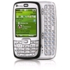
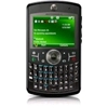
PathAway is now available on
Windows Mobile Smartphone
|
|
  The latest builds include a
pre-release of PathAway for Windows
Mobile Smartphone running Windows Mobile 5 or
higher. This version has all the features of the Pocket PC
versions with extra features to allow full control of the
application without the need of a touch-screen. The latest builds include a
pre-release of PathAway for Windows
Mobile Smartphone running Windows Mobile 5 or
higher. This version has all the features of the Pocket PC
versions with extra features to allow full control of the
application without the need of a touch-screen.
This version works on the most popular Windows
Mobile 5/6 Smartphones such as the Motorola 'Q', HTC
S710, HTC S621, Toshiba Portege, HTC S630, Samsung
BlackJack/SGH-i600, HP iPAQ 510, HTC Qtek 8500, Dopod C730,
i-mate Smartflip, HTC S620, i-mate SPL, HTC MTeoR, Samsung
i320N etc.
Download the
latest version to try PathAway on your WM Smartphone.
|
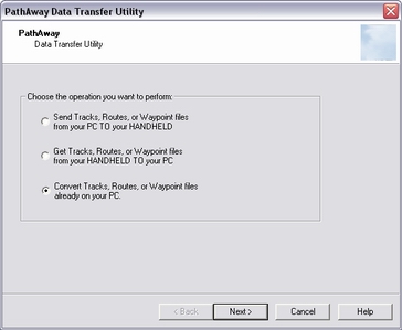
PathAway
Data Transfer Utility
for Windows
FREE
|
|
The PathAway Data Transfer Utility (DTU)
is an easy to use Windows-based wizard-style
utility for converting and transferring tracks, routes, and
points to and from your handheld. Now transfer files such as
GPX, LOC to PathAway, and get PathAway data from
PathAway and convert into GPX, LOC, KML or other
formats.
The DTU program is now included in the latest
version of PathAway, or can be downloaded seperately at http://pathaway.com/convert.htm.
To Transfer data, simply run the program and follow the
steps to do the conversion and transfer of your data. If you
don't want to transfer to the device, you can simply run the
"Convert" command to convert from one format to another.
System Requirements:
- For Windows Mobile, ActiveSync must be connected for
direct data transfer.
- For Palm OS, the data is extracted from your Palm Backup
folder. On send, data is added to the Palm Installer. You
must HotSync to transfer the data to the Palm OS device.
Formats Supported:
- PathAway Delimited Text,
- PathAway PalmOS PDB
- GPX and LOC (Geocaching formats)
- KML (Google Earth Keyhole Markup language),
- CSV (Text Commad Delimited)
- OZI PCX5, OZI Track,
- Waypoint+ (Garmin)
You can also define your own delimited data format to use
for transfer by creating your own .CAL file and placing it in
the Program folder. See information on the .CAL format at http://pathaway.com/convert.htm.
|
PathAway + Maps
on SD-Card
New product
from Navisat delivers PathAway and maps of
Czech Republic and Slovakia.
|
|
 Navisat's new product
"TourNavigator" includes PathAway and their entire collection
of maps in PathAway format on a single SD-Card. Navisat's new product
"TourNavigator" includes PathAway and their entire collection
of maps in PathAway format on a single SD-Card.
Simply slide in the card, and go. SD card contains an
auto-install of licensed version of PathAway GPS 4 Standard
Edition.
Visit www.TourNavigator.cz or www.navisat.cz to purchase
the TourNavigator product. Navisat plans to expand it's
offerering to other locations in Europe so keep checking with
them for other maps you may be interested in.
|
PathAway GPS
4 - Professional Edition
for Windows Mobile
|
|
PathAway Professional Edition has all of
the features
of PathAway GPS 4 - Standard Edition plus new features
targeted towards power users and
professionals. Of significance, PathAway PRO
has 2-way wireless remote location tracking. See where others
are right from your handheld, share your location with others,
or send to a central tracking service. Also, PathAway PRO can
now download maps on-the-fly from the internet via the new
WebMaps feature.
Send My Location: 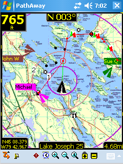
Send your current GPS location to another user or remote
tracking service via SMS or Http protocol. See PathAway
Send/Receive Format document for the
supported send formats. Send manually via
command, or have location sent automatically based on preset
intervals.
Retrieve Remote Locations
As new Remotes are retrieved, they are assigned a default
background color for display on the map. This color can be
modified by Editing the Remote Item Info. Remotes are tracked
by their ID passed along with the location message. The Label
for a remote can be modified by the user for easier on-screen
identification.
Retrieval is achieved either when an SMS message containing
location information is received, or via automatic or manual
polling of an Http-based Tracking server.
For Servers that return timestamp information, PathAway
will download only updated location information.
On-Map Remote Labels:
- For each remote location being tracked, the tag on the
map can display current location and heading of remotes,
course, speed, elevation of remote, date/time of retrieval,
distance to, course to, and elevation difference.
Web Maps - Download maps from the web (Internet connectivity
required)
Designed for Phone Edition Pocket PCs, Web
Maps allows you to download maps on-the-fly from a Map Server.
Maps will be downloaded in the background and displayed on the
screen as they complete downloading. Maps are cached, so
downloading only needs to be done once.
Currently
supported map servers:
Google Maps: Worldwide
street and satellite maps.
Terraserver-USA
Maps: USGA Topographic and aeriel photo maps. Covers
USA only.
Calculate Location by Vector
Calculate a new Location by entering a distance and course
from a starting location.
Available from Goto Location and
Point Edit Location dialogs. Great for geocaching when you're
provided only with a course and distance vector from your
current location.
Directional Alarms
- In addition to the off-track and altitude warnings, turn
instructions, and proximity notifications, PRO now offers
different alarm sounds for left and right turns, left and
right of off-track warning, and high and low elevation
warnings.
Custom Alarms can trigger external
programs
- Set the alarm sound in a Point to "EXEC <url or
program name>" to have PathAway launch a special program or
call up a Web Page when the proximity to the point has been
reached. Great for tour guide application.
Map Display
- Views of Distance Radials on Map. See View->Map
Display... settings. Displays distance radials in predefined
distance rings.
Find Location by Street Address Lookup: (Internet connectivity
required)
Enter a street address, then choose from the closest points
found. Choose whether to show the point on the map, add a new
point, or navigate to the address location.
New Find Location Dialog
- New Find Location dialog is now a Wizard style to provide
step-by-step assistance on finding the location you're looking
for. Options include: select location by coordinates, Online
Street Address lookup, Point database lookup, or start of
track or route locate. Once found, choose whether to show the
point on the map, add a new point, or navigate to the new
point.
User Interface Improvements
- Added New UI Elements including Reorganized Menus.
Optional Text-based tools option for one handed control. (See
View->Text Menus). Switch directional arrows between
Zoom map, Scroll map, select item on map, and select dashboard
item.
- GPS Status added as a Dashboard option.
- "Show
Note" to Point Context Menu. Displays note text of waypoint.
Also, a 'T' icon will show on the Proximity Dash item. Click
on the 'T' to show the waypoint Notes.
- Screens made
square and widescreen aware.
- UI Screens now utilize
Windows Mobile 5 command key buttons.
PathAway Map Manager
- Basic support added for OZIExplorer .map and .geo import.
Currently supports multi-point calibration in "dd mm.mmm"
format. Open the map by bitmap name (ie. map.jpg) and PathAway
will look for an associated Map or .geo calibration file.
-
Map Manager, support for PNG, GIF and TIF files.
|
|
PathAway Mac Map
Manager
Pre-Release
available for Download |
Updates
- Get the Latest Software Revisions
|
|
Remember that updates for minor revisions are FREE.
This means if you are running version 4.00.39, then
you can download and install version 4.00.71 for FREE.
If your version number starts with a 4, then all revisions
starting with 4 are free.
We are actively updating the software on a regular basis.
Check your version number that appears on the 'About PathAway'
screen on your Handheld, against the posted latest version on
PathAway.com.
To install the latest, simply go to the Download page and
install over top of your current version. Your data will not
be affected. If your version is quite old, you may need to
reenter your Registration key, so make sure you have it handy
before installing.
Latest versions are as follows:
PathAway GPS 4
Standard Edition for Windows
Mobile
v4.00.71, Sept
9, 07
- Improved: Map Calibration
using Nudge controls and 3point editing controls.
- Added:
Map Calibration: Rotate calibration by left and right
angle
- Added Data Transfer Utility and PWDBConvert:
Support for import multiple types in single GPX files.
-
Added GPX import: Support for additional tags such as
" symbols and extra geocaching tags.
- Fixed: Icons not showing in
Select Point dialog.
- Added: Device only, Support for
import multiple types in single GPX files.
- Added -
Editting of Projection Parameters on Windows Mobile.
-
Fixed: 3pt calibration dialog reappearing after closing then
changing screens.
- Added -
Detection of External Media Insertion/Removal. On a media card
change PathAway will now load and unload maps and data
automatically.
- Added - Options/Preferences/Tracking:
Record 3D fixes only
- Added: Total Distance, Area info to
"Details" dialog for Routes/Tracks
- Modified PocketMode.
To address devices with only 2 hard keys, PW will now exit
Pocket mode with any combinations of 2 hard keys. For Keyboard
devices, 'Q' followed by ''P' will exit Pocket Mode, or '1'
then '3'..
- Fixed: Track/Route occasional rendering
problems.
- Fixed: Not saving "Enabled" and transp mode
flags when a large number of tracks/routes/maps/point
databases are installed.
- Fixed: Point Details- Show on
Map menu option not working
-
Improved: Hard Keys for Zoom now do not repeat on press and
hold. Now next Zoom is initiated for each button press.
-
Added: Manual Route Advance. At the end of the route, Advance
will ask if you want to go to the start of the
route.
- Added: 19200 baud
rate.
PathAway GPS 4
Professional Edition for Windows Mobile:
v4.00.71, Sept 9, 07
- Improved: Map Calibration using
Nudge controls and 3point editing controls.
- Added: Map
Calibration: Rotate calibration by left and right angle
-
Added Data Transfer Utility and PWDBConvert: Support for
import multiple types in single GPX files.
- Added GPX
import: Support for additional tags such as " symbols
and extra geocaching tags.
- Fixed: Icons not showing in Select Point
dialog.
- Added: Device only, Support for import multiple
types in single GPX files.
- Fixed: Set Distance in
Kilometers, Distance Radials still plotted in Naut.
Miles.
- Added - Editting of Projection Parameters on
Windows Mobile.
- Fixed: 3pt calibration dialog reappearing
after closing then changing screens.
- Fixed: Send Log info
being added to GPS Log
- Added -
Detection of External Media Insertion/Removal. On a media card
change PathAway will now load and unload maps and data
automatically.
- Added - Options/Preferences/Tracking:
Record 3D fixes only
- Added: GPS Accuracy reporting to
dashboard: PDOP, HDOP, VDOP, and Track PDOP, HDOP, VDOP.
- PDOP, HDOP, VDOP, Accuracy, added to track log and
GPX export.
- Added: Total Distance, Area info to "Details"
dialog for Routes/Tracks
- Modified PocketMode. To address
devices with only 2 hard keys, PW will now exit Pocket mode
with any combinations of 2 hard keys. For Keyboard devices,
'Q' followed by ''P' will exit Pocket Mode, or '1' then
'3'..
- Fixed: Track/Route occasional rendering
problems.
- Fixed: Not saving "Enabledand transp mode flags
when a large number of tracks/routes/maps/point databases are
installed.
- Fixed: Point Details- Show on Map menu option
not working
- More improvements on SmartPhone version. inc.
backspace and Clipboard support for text
- Improved: Hard Keys for Zoom now do not repeat
on press and hold. Now next Zoom is initiated for each button
press.
- Fixed: Saving options: GPS Log filename, Selected
Sentences, maximum log size
- Added: Manual Route Advance.
At the end of the route, Advance will ask if you want to go to
the start of the route.
- Added:
19200 baud rate.
PathAway GPS 4
Standard Edition for Palm
OS
v4.00.71 Sep 11,
07
- Added Import GPX: Support for larger GPX
files.
- Improved Map Calibration using Nudge controls and
3point editing controls.
- Added GPX import: Support for
additional tags such as " symbols and extra
geocaching tags.
- Added support for import multiple
types in single GPX files.
- Added support for OZI
maps Transverse Mercator projection with only 2 calibration
points
- Added -
Options/Preferences/Tracking: Record 3D fixes only
- Added:
Total Distance and Area to Track/Route Details dialog.
-
Added: Manual Route Advance. At the end of the route, Advance
will ask if you want to go to the start of the
route.
PathAway Map
Manager:
- Added support for OZI maps
Transverse Mercator projection with only 2 calibration
points
- Added: Map Manager now gets
the registered folder names from ActiveSync.
PathAway Data Transfer
Utility:
- Now included in
regular install.
- Added GPX import: Support for additional
tags such as " symbols and extra geocaching
tags.
- Added support for
import multiple types in single GPX files.
These latest revisions are FREE if you
have a registration key for any version 4.x of PathAway. These
revisions contain new features and increased stability. Check
the Release Notes for details on the
improvements.
|
About
PathAway GPS 4
|
|
If you work or play in the outdoors, PathAway is
the companion to take with you.
For Outdoor Recreation: PathAway provides
affordable navigational support for aviation, boating,
automobile (on and off-road), hiking, cycling, touring, rally
racing, motorcycle touring, ballooning, scuba diving, fishing,
hunting, paragliding, mountain climbing, ultra-light flying,
canoeing, snowmobiling, athletic training, outdoor education,
geocaching, and more.
For Professional
use: PathAway's powerful feature set makes it a great
tool for mapping/GIS, mining, military mapping, surveying,
site inspection, personnel training, education, telematics,
field data collection, archaeology, security, search and
rescue, asset management, agronomy, or any application where
location is important.
Standard Edition Key
Features:
- Palm OS and Windows Mobile Platforms.
- GPS Navigation with most GPS Devices (including
Bluetooth)
- Import your own Maps using PathAway Map Manager
- Intelligent Moving Map Display
- Map Projections, Grid, and Datum support
- Add Personal Points of Interest/Waypoints
- Record and Follow your Tracks
- Track, Multi and single Point-to-Point Routing
- Navigation Warnings and Alarms
- Onscreen Trip Statistics on a Customizable Dashboard
- Large Compass Display for position status at a
glance
- Palm OS and Windows Mobile versions
- Import and Export of GPX, LOC and Delimited formats
- Transfer Data To and From GPS Devices
Professional Edition Additional
Features:
- Send/Receive Locations via SMS or Http protocol.
- Monitor Remote Locations
- Calculate Location by Vector
- Directional Alarms
- Custom Alarms can trigger external programs
- Find Location by Street Address Lookup
- Download Web-maps on-the-fly
Platforms
Supported:
- Palm OS 3.5 and higher
- Windows Mobile - Pocket PC 2002 (SE only)
- Windows Mobile - Pocket PC 2003
- Windows Mobile 5 - Pocket PC
- Windows Mobile 5 - Smartphone
- Windows Mobile 6 - Professional (Pocket PC Phone)
- Windows Mobile 6 - Classic (Pocket PC)
- Windows Mobile 6 - Standard (Smartphone)
Visit us at
PathAway.com for all the details
|
Thanks for reading the
PathAway Newsletter! |
|
We hope you appreciate the PathAway Newsletter.
We endeavor to make your experience with PathAway as rewarding
as possible, so if you have any comments, please don't
hesitate to contact us.
Enjoy,
The PathAway Team
| |
|
| |
|
|