Products on iOS


for iPhone, iPad, and iPod
GPS Navigation, Tracking, Route Planning, Offline Mapping
-
Use GPS to navigate
Route Planning and mapping
Define or import routes to follow
Define or import favourite points to find
Record track log to find your way home later.
Download Free Online Maps
Access downloaded maps without a data connection
Upgrade to Express or PRO via In-App purchase.
- Languages: English, German, Italian, Spanish, French, Swedish, Czech, Portuguese,
-

PathAway is the all-purpose GPS Navigation software.
PathAway provides affordable navigational support for aviation, boating, automobile (on and off-road), hiking, cycling, touring, rally racing, motorcycle touring, ballooning, scuba diving, fishing, hunting, paragliding, mountain climbing, ultra-light flying, canoeing, snowmobiling, athletic training, outdoor education, geocaching, mapping/GIS, mining, military training, surveying, site inspection, telematics, field data collection, security, search and rescue or any application where location is important.
If you get out and go places, PathAway is the companion to take with you.
PathAway software has evolved from real customer usage over that past 15 years. The iOS version represents the culmination of our experience building world-class software trusted by the most demanding users. Here's an early user review from the iTunes app store that descibes the user experience well:

By KootenyGuy - on iTunes App Store - 26 Jan 2011
Only GPS App you will need for the backcountry
This is it...The only GPS app you will need for backcountry activities
like cycling, sailing, hiking, or anything else that takes you off the
beaten track! PathAway has been a full featured favourite on Palm and
Pocket PCs for years and is finally available on the iPhone. I've tried
other hiking and biking apps but nothing comes close to PathAway in
versatility. I love the ability to create and import custom maps which
show all the detail I need to create routes and navigate on the fly.
Routes can be as simple or complex as I want or need. Maps showing
different features and levels of detail can be layered on top of each
other. Custom dashboards display realtime tracking and navigation
information. Scott and his PathAway team have done a great job of
putting the backcountry at our iPhone fingertips.
See more customer reviews here.
PathAway Key Features
GPS Navigation
Use the embedded GPS in your iOS device and use PathAway to navigate.
Maps from Anywhere (Express Edition or higher)
Import or create your own maps using our free Map Manager.
Get maps from mapping web sites, CD-ROM,
scanned, or digitally photographed. Maps are highly compressed
and can be any size and resolution that fits within your device
memory.
WebMaps - Download Internet maps on-the-fly
Web Maps allows you to download maps on-the-fly from
a Map Server on the internet. Maps will be downloaded
in the background and displayed on the screen as they
complete downloading. Maps are cached, so downloading
only needs to be done once.
Maps currently supported:
Google Maps: Worldwide street, satellite,
and terrain maps.
Terraserver-USA Maps: USGA Topographic and aeriel
photo maps. Covers USA only.
OpenCycleMap.com: User contributed topgraphic and terrain maps. Covers most of World
ArcGIS World and USA Topos: Free Topographic maps provided by ArcGIS
Natural Resources Canada Topos: Free Topographic maps provided by NR Canada
FAA USA Sectional Charts: USA and South Ontario Aeronautical charts provided by the FAA.
As you travel, PathAway will center the map on your position and download the map sections needed to guide your way.
Coordinate Grids:
Display positions in coordinates such as Latitude/Longitude,
UTM, OSGB, Quebec-MTM, MGA, MGRS, GGRS87, Swedish Grid, Irish
grid, or Israel Grid and more.
Personal Points of Interest/Waypoints
Capture an unlimited number of georeferenced points, and record detailed names and descriptions.
Attach your own custom icon, for easy
visual scanning.
Record and Follow your Tracks
Record your track as you travel. Then, follow the recorded track to
find your way home. PathAway can store an unlimited number of track
logs which can be selected at any time for navigation or analysis.
Point to Point Routing
Create routes quickly by simply clicking points on a map,
or by choosing from your point database.
Navigation Warnings and Alarms
Proximity detection alerts you to upcoming points along your
route, or when you get close to one of your points. If you're
following a route, PathAway will alert you if you've strayed
off-track, or if your elevation has strayed beyond the level
stored in the route.
Compass View
Customizable Large Compass view screens showing Heading,
Direction to Next Point, or any other available
navigation data. View multiple Compasses on the screen at
the same time, or a single large compass.
Import/Export Data Formats
Google Earth KML, KMZ, GPX, LOC, and other formats directly on your handheld.
GPS fix acquired and lost alarms
Receive audible alerts when a GPS fix is acquired or lost.
Onscreen Trip Statistics on a Customizable Dashboard
Display the information you need while still having a great
view of the map. Custom 12 edges of the screen to pop-out
to show the info. Stats such as ground speed, average and
max speed, and vertical climb/descent speed. elevation, geographic
coordinates, directional heading/ ground distance/vertical
distance/vertical angle to next point, or destination.
Odometer, elapsed time, Estimated time en route.
Features
Global Positioning System (GPS)
PathAway navigation system uses satellite signals to determine your exact location, speed and direction of travel. PathAway uses the built-in internal GPS of the iOS devices.
GPS is not required to use the software. You can still browse maps, create routes, and mark points on the map.
Navigation
- GPS support for most devices.
- Customizable screens can display current location, elevation,
speed, direction, plus navigational information such as distance,time,
and direction to destination. Over 30 different display options
available.
- Moving map centers on your current location.
- Record your track for later back-tracking, or reviewing
the journey.
- Proximity notification displays points you are approaching,
their distance away, and position relative to your direction
of travel.
- Big Compass screen can show your most important information
at a glance. Customize the Compass to suit your needs.
WebMaps:
- Use online maps from OpenStreetMap, OpenCycleMap, Google, and USGS Topos;
- Maps are downloaded on-the-fly as you travel;
- Maps can be cached for off-line use when connectivity is not available;
Points
- Capture and mark unlimited number of points and locations.- Use long names and descriptions for easy recognition.
- Apply an icon to each point.
- Goto points on the map, or points along a track.
Routes
- Create routes by simply clicking points on a map, or by
adding points from your Points database.
- Choose a recorded track to follow.
- Follow routes either forward or reverse (back-track). Great
for finding your way home.
- Simulate (play) your route travel before you go.
- Determine your total distance and estimated travel time
to destination. Time can be estimated by current speed, average
speed, or a custom speed setting.
Tracks
- PathAway can record your location at regular intervals
as you travel with a GPS.
- The track line is displayed on the map as you travel.
- You can then reuse the track to follow at a later time.
- Time and distance are recorded in the track log, useful
for accurate travel planning.
- All track points can be added to your points database.
Screen Views
Full Screen Map View - Utilizes most of the screen to show as large a map area as possible. Long/Lat, speed, elevation, and direction of travel are displayed. This data is the “navigation” data in the program.
Tracking View - Shows the map and navigation data. Default travel stats are related to information specific to your current trip.
Route View - Shows the map and “navigation” data, plus full info for point proximity. As you approach a point, “Estimated time to next destination (ete)”, “Distance to” and “Course to” are displayed.
Compass View - Shows the navigation Compass and selected “navigation” data.
The Compass view is customizable. The screen can display data in a “Tiled” format, or a single Compass in full screen.
User Interface
- Preferences for distance and elevation units, course display,
time estimation, proximity notification, map display detail,
and track recording precision.
In-Hand Data Management
- Edit point, route, and track databases
- Import and Export between GPX, LOC, KML, and text delimited formats.
PathAway Main Screen Components

PathAway Reviews
Its official, PathAway is a HIT! We've had an incredible
response from customers and reviewers. Check out this feedback:
By Free Apps for Me - FreeAppsForMe.com
PathAway chosen to be listed in "Best Offline Navigation Apps"!
Every person, at least once in their life, gets into a situation where they are in an area they've never been, and there are no maps available to guide them. Never mind! After all, PathAway is the very app that will help you forget about such situations. This app is suitable for absolutely any user, be you an ordinary worker, tourist, logist or even a trucker.
Read the full review on Free Apps For Me
By Jonah Chalapan>
Pathaway is best app for outdoor navigation as I know.
By
Best Offline GPS Navigation Apps For Android - SmartTip.org
Review for PathAway on Android
Pathaway is one of the unique GPS app you may find. The features that it offers are amazing and extremely useful!
Read the full review on SmartTip.org
By Apps Like These - AppsLikeThese.com
Review for PathAway on Android
The app can be a great helper for you! We like the fact that in this application you can develop a route by setting points on the map. In the advanced versions, you can also add the weather to the map, or even make your (own) map!
Read the full review on AppsLikeThese.com
By Free Apps for Me - FreeAppsForMe.com
Review for PathAway on Android
If you have traveled at least once, you know how difficult it is to find a good map or navigator that will work even in the forest or in the mountains. Meet PathAway Outdoor GPS Navigator, THE BEST ONE for off-road driving, hiking, and other travel activities.
Read the full review on FreeAppsForMe.com
By Android Apps for Me - AndroidAppsForMe.com
Review for PathAway on Android
Meet PathAway – the navigator that will make you confident on the path of daily activities. After a welcome screen and a reminder to turn on GPS, you see a map of the area where you are. The appearance of the map is similar to Google Maps but prettier.
Make your journey online or offline. The application is always stable. And if something is unclear, technical support is always ready to advise. These guys have been in mobile GPS for over twenty years, so you can safely trust your path to them.
Read the full review on AndroidAppsForMe.com
By [APP]Pearl - AppPearl.com
Review for PathAway on Android
Don’t let yourself get lost from the path while achieving your goals. Don’t waste time looking for your way – trust your PathAway navigator.
The application is reliable in operation, so it will carefully guide you and be your pharos in the wilds of daily affairs. The PathAway technical team has (over) 20 years of experience in GPS applications and is absolutely professional.
Read the full review on AppPearl.com
by Ferdinand - Germany
The best smartphone Outdoor Navigation I know.
by Joel (MobArmor) - USA
The interactions of the app and its functions have been very positive.
We had some great test time on the app this past weekend and showed it off to a large crowd of people. There was a very positive reaction from sample consumers.
They really liked that this app is for both Apple and Android phones.
- We have tried loading race courses into the app and it is very easy. The app accepts GPX files and displays them nicely.
- We ran the app frequently on an iPad mini over last weekend while we we're doing some off-road testing and the battery life of the tablet was surprising how long it lasted on a single charge.
- Background tracking was very nice, it seemed to get GPS lock and never let it go!
- This allows me to start GPS tracking, turn off the screen to save battery and throw my iPhone in my backpack when we go off into the hills on motorcycles. When we stop or get lost I open the app and see everywhere we have been accurately.
- The app is very easy to customize with different dash layouts and color choices. This is awesome.
- I really like the ability to label points of interest and have them display.
by Atgiris - Greece
The best gps mapping app for outdoor activities!!!
Very easy to use and very helpful when needed.
I'm using it since 2003 on a garmin ique and now the android version is just excellent!!!
by Jens-Arne - Germany
PathAway for Android
Extremely sophisticated, highly user customizable routing and tracking app, even allows for real time weather overlays and position following by other users.
by Jim - Arizona
Great new GUI (Graphical User Interface)!
by Angela Clements
Best map app. Works every time and accurate!
by Walter - Germany
PathAway for Android
I would like to commend your program today. On my hike over the Alps (125 km) worked PW5 Pro without error. My tracks were recorded properly and on the external SD exported (Android 4.4.3). I was reliably performed on the track. The program is fast. It works without a long delay. The map view is very good for me.
PW5 Pro is for me still the best program.
by Richard M - Australia
PathAway for iOS, Windows Mobile
PathAway has to be the best moving map app I've used, and it seamlessly integrates with Fugawi Global Navigator which I have used on the PC for many years and is how I came to PathAway in the first place.
So please keep up the excellent work and a fine product!
by Dr. Thomas E - Germany
PathAway for Android, iOS, Windows Mobile
Many thanks by the way for your great piece of software which was one strong reason to go for Android after a period of time with iOS and many years of windows mobile with PathAway.
by G Hill - Germany
PathAway Express Edition for Android
Activities: Cycling
Please continue developing this extraordinary software!!
John H - U.S.
PathAway Express Edition for Android
Activities: boating, hiking, hunt, geocache, mapping, forestry
BernD - Germany
PathAway PRO Edition for Android
Activities: cycling
Marquetta B - U.S.
PathAway Express Edition for Android
Activities: off-road
Hans F - Thailand
PathAway Express Edition for Android
Activities: auto, aviation, hiking, mapping
Since last update now runs quite good.
G. Max - Germany
PathAway Express Edition for Android
Activities: hiking, cycling, geocache
Excellent. Use it since long time. Heard about from a collegue.
Walter R - Austria
PathAway PRO Edition for Android
Activities: navigation
Kjell F - Sweden
PathAway PRO Edition for Android
Activities: hiking
Starting quickly, all (and more) necessary functions. Compared with my earlier program (Fugawi Global Navigator) more stable.
Gunther H - Germany
PathAway Express Edition for Android
Activities: hiking, cycling
Powerfull app!!!! Please go on developing!!
By Holger - on Expedition Portal
Review for PathAway Express on iOS
For me the best navigation app out there...
I used it for years on the Palm and absolutely loved it. Since the Express version for iPhone/Pad is out I bit the bullet and bought it, and again
absolutely love it.
I handles your own Bitmaps as well as downloads online maps.
It works with TTQV, Ozi and Fugawi. It caches the maps it downloads, so you don't need to download them again.
I have for example all the Hema Great Dessert Tracks (Australia) on my iPhone,
and quite a view other Bitmaps (Topos) of my local area.
Since I have Pathaway I have not once used any other GPS App.
Got all of that in the one app.
Clear thumps up from me...
By GPS Viajero (Spanish)
Review for PathAway on Android
PathAway has long been the best program for GPS to iPhone, Palm and Windows Mobile and Android is finally present.
(Original)Pathaway fue por mucho tiempo el mejor programa para GPS para iPhone, Palm y Windows Mobile y finalmente esta presente para Android.
Powerful and versatile GPS application for any recreational or professional use outdoor app... Read More
By Walln - on iTunes App Store Austria
Review for PathAway Le
Perfect for Offroad Navigation!
Absolutely great for the off-road navigation.
By g11nMike - on iTunes App Store USA
Best GPS App yet!
I have looked at, installed, or bought more than eight different GPS and mapping apps so far, and Pathaway is the best so far for what my particular needs and interests are. A little bit of background, first. I was looking for an app that handled topo maps well, would allow me to load custom maps, e.g. trail maps, geology maps or campus maps, had good tracking, good zoom in and out, map layers, and customizable data displays for my middle-aged eyes to choose what I thought was important to display. I tested on an iPod Touch 3g with a DUAL GPS cradle.
Here are the features I really really like:
- dynamic map uploads from OpenStreetMaps, TerraServer, etc. This works very well when I am connected.
- caching of web maps. This is a must for me, since I am using an iPod Touch without a wireless connection. -
- ability to work in the background, after hitting sleep. This is a big bonus for me. I was able to track hikes all day on one charge using this little gem. My particular GPS cradle uses its own battery for the GPS, and with PathAway running in the background, like music player, I could go six hours and still have 60% charge left. I would only switch the screen on at junctions or to get bearings, maybe every 30 min or so - and my position was up to date, along with my track and progress.
- ability to load my own maps. Using the external utilities from the PathAway site, I can load all the USGS geoTIFF maps I want, and PathAway knows how to zoom and scale between different map resolutions. This was a major pain for me in another popular topo map app. Pain gone, now that I am using PathAway. Another big plus, is that I can use Google Earth KMZ files, or even images from other areas. I have old geology maps of my area which I was able to scan, and easily designate lat/lon points on it, and voila! I have another map layer to add to my web maps, USGS maps, and plot layout maps. Just remember that your maps have the suffix ".prc" - probably left over from Palm device days. Oh! and you can import maps created for Palm Windows CE, and other devices over the last many years.
- ability to customize the display. When driving, I like to see my speed. In a BIG font. I can do that with PathAway - I can choose what gets displayed, how big, and where on the screen.
- easy to export and import maps and tracks. I don't have to mess around with a klunky i-thing web server that never works at work. Just use the iTunes files transfer in the device apps tab.
This looks expensive, but I have paid much much more for less functionality on other devices. The inexpensive Lite version also allows uploading tracks, and may suit your needs, but I am quite happy with the Express version. All my other topo and tracking apps will be gathering dust now that I have PathAway.
By world28 - on iTunes App Store France - Translated from French
Finally! View GPS raster maps on the iPhone
Finally, the raster maps on the iPhone!! And it works great. It's like the Palm, where it worked very well for years. Go through Dropbox, mobileme for transfer over the network, or FileApp or Flash Drive to load the file with the itunes sync (very fast). Really. Now that we have the ability in iTunes to have the file exchange, it is 5 stars. The iPhone has become a great tool for GPS field, really useful. The online web maps are nice, but not good enough for hiking trips for the experienced or in deserted areas (with Touratech 4 for example). All other programs have fallen behind now! MAJ. You can put the cards directly from iTunes and sync goes really well and very fast.I just do the test with maps of India exported for Pathaway (Palm) and is fully compatible. So just super. Now, the dream tool is here!!. Bravo developers!
Original French version: Enfin les cartes raster sur l'iPhone !!!! Et ça marche super bien. On se croirait sur le Palm où cela fonctionnait super bien depuis des années. Passer par dropbox, mobileme pour transfert via le réseau, ou FileApp ou Flash Drive pour charger le fichier avec la sync itunes (très rapide) . Vraiment bien. Quand on aura la possibilité dans iTunes d'avoir l'échange de fichier, ce sera 5 étoiles. Mais déjà là, l'iPhone est devenu un super outil de GPS sur le terrain, vraiment utile. Les web cartes sommaires, c'est bien, mais pas assez bonnes pour les balades en rando par exemple ni en expé dans des zones désertes (avec Touratech 4 par exemple). Tous les autres logiciels ont un paquet de retard maintenant... MAJ. On peut mettre les cartes directement depuis iTunes et la synchro se passe super bien et c'est très rapide. Je viens de faire le test avec les cartes de l'Inde exportée pour Pathaway (Palm) et c'est totalement compatible. Donc tout simplement super. Maintenant, des petites retouches d'apprence, et l'outil rêvé est là !!!! Bravo les développeurs!
By KootenyGuy - on iTunes App Store Canada
Only GPS App you will need for the backcountry *****
This is it...The only GPS app you will need for backcountry activities like cycling, sailing, hiking, or anything else that takes you off the beaten track! PathAway has been a full featured favourite on Palm and Pocket PCs for years and is finally available on the iPhone. I've tried other hiking and biking apps but nothing comes close to PathAway in versatility. I love the ability to create and import custom maps which show all the detail I need to create routes and navigate on the fly. Routes can be as simple or complex as I want or need. Maps showing different features and levels of detail can be layered on top of each other. Custom dashboards display realtime tracking and navigation information. Scott and his PathAway team have done a great job of putting the backcountry at our iPhone fingertips.
by Goosilein - on iTunes App Store Germany - (translated from German)
This is it!
Perfect! This is THE off-road GPS navigation program in general. There is no better and certainly not at that price. In addition to online maps now has imported TTQV calibrated maps in PathAway format. Import and export of tracks and routes to function properly with various file formats.The support by the developer is very quick and exemplary. Clear recommendation for all those of the functionality of the Express version is enough. For me, the most "killer features" now implemented.
Das ist Es!
Perfekt! Das ist DAS offroad GPS-Navigationsprogramm schlechthin. Es gibt kein besseres und schon gar nicht zu diesem Preis. Neben Online Karten können nun auch z.B. mit TTQV selbstkalibrierte Karten im PathAway-Format importiert werden. Import und Export von Tracks und Routen funktioniert einwandfrei und mit verschiedenen Dateiformaten. Der Support durch den Entwickler ist sehr schnell und vorbildlich. Klare Empfehlung für alle denen der Funktionsumfang der Express-Version ausreicht. Für mich sind die meisten "Killer-Features" nun implementiert
by Fantasiakreuzfahrt - on iTunes App Store Germany (translated from German)
At last, all my maps on the iPad
I've been waiting for an app to display any maps, and relatively simple. Relatively because the transfer of own maps is a bit complicated. The killer app for offroad navigation: Custom maps, Web Maps, own waypoints, routing, tracking, configurable interface, what more could you want?
by CesarH - on iTunes App Store Brazil (translated from Portuguese)
Review on PathAway LE
Very Good
Great program for navigation off road. Already known from other platforms like Palm and Windows Mobile.
Ótimo programa para navegação fora da estrada. Já conhecido de outras plataformas como Palm e Windows Mobile.
by Aung Mau- on iTunes App Store Thailand
Review on PathAway LE
Best GPS navigation App for iPhone
I have been using PathAway since 5 years ago on Windows Mobile and it was my favorite application. When I switched to iPhone 2 years back, since then I have been waiting PathAway for iPhone (iOS). There are lots of GPS navigation applications for iPhone but if you really start using this PathAway, you will know the difference at once and will love it. All features are there except importing customized maps in this LE version. This app is the best GPS Navigation App for iPhone.
by AOrosa - on iTunes App Store USA
Review on PathAway LE
Works Great!
I use to have Pathaway in other devices. Excellent program now in iPhone!
By KootenyGuy - on iTunes App Store Canada
Review on PathAway LE
Fantastic App for the backcountry
I've used and loved PathAway on my Palm handhelds - for years of fun and safety while navigating the Canadian backcountry and long distance walking in Europe. The upcoming Express Edition promises to be just as useful and better looking - with the ability to calibrate and upload custom maps. With custom maps, nothing will be able to beat PathAway 5 for iPhone for awesome flexibility. That will make it a 5 out of 5 stars! In it's present "lite" form it still works well (especially the ability to easily add waypoints and build routes on the fly) and is worth a try.
Gerhard S.
I have used Pathaway for many years along many country paths in Germany and Italy. I can highly recommend the new portable phone Pathaway for Symbian! I use it on a Nokia 6710 Navigator. With PathAway you can use your own maps when navigating off-road. By its clever programming, all necessary functions could be implemented on the tiny phone-keyboard. External GPS devices work fine and help spare battery power of the Nokia. The installation with Nokia Suite runs flawless.
Tom P.
With PathAway, you can create your own maps, even aerial photos, and import them. I have downloaded topos, marine charts, aerials, street maps and sectionals. The cool thing is that you can layer maps and switch between them. I have used this for flight, boating and hiking.
VARIFRANK blog titled "The Batman Utility Belt"
Pathaway. Ahhhh. Pathaway. The “GPS
tool of the gods”. Pathaway quite literally
does everything that you would want a good GPS to do. Its ability to allow you to make your own maps from
topology mapping software makes it particularly helpful
when you are off in the woods. Its real selling point
is the use of GPS Remote Tracking (PRO Edition Only), allowing you to track
other PathAway users or allow other pathaway users to
track your position from either their own pathaway systems
on their phones or on a website. GPS tracking is the
killer app for GPS systems but tie a GPS to a cellphone
and its really fantastic.
Softonic - On Software - Review of Mobile GPS Applications - The best mobile GPS software
PathAway GPS : This is probably the best of
the GPS apps we tried out, mainly because of its huge
range of features. Perfectly suited to orienteering,
trekking, mountain-biking and other outdoor pursuits,
it combines the accuracy of GPS location technology
with high-powered path-finding and recording tools.
http://en.onsoftware.com/the-best-mobile-gps-software/
German publication Navi Magazin gives PathAway 4 a "VERY GOOD" rating.
PathAway Standard and Professional have tons
of features and excellent operation. The developers
really listen to their customers in the forums and the
update cycle is short (sometimes a week between updates
with new features). Aside from customization, PathAway
comes with some very handy features that work
together very well. Overall I am impressed with the Remote Location Tracking
and web maps, they worked flawlessly. The functionality
of PathAway Pro is very impressive and valuable
to a traveler or work force. The responsiveness of the
developers to their clients, and the turning out of
updates is wonderful... If you are going to place bets on GPS software, put
the money down on PathAway Pro because MuskokaTech
has hit a home run with PathAway Professional.
PathAway GPS 3 Review I'll have to confess that this is one of those applications
I didn't know how much I could use until I tried it
out. When I did, I found a number of potential applications.
The program is flexible enough that the only limit to
making it work with location-based applications is your
imagination. The question is not really "What can it
do?", but "When it comes to GPS, what can't it do?"
As you begin to see the wealth of applications, the
$50 price tag looks all the more reasonable. In fact,
as I'm writing this, I'm surprised the program is
as inexpensive as it is for all the features it offers.
If you're looking for a GPS application to help you
while you travel by virtually any mode of transportation;
if you're looking for a GPS application that can take
you virtually anywhere; if you're looking for a GPS
program that isn't limited by the maps that come on
the product CD; this is it. Look no further.
German: English Translation: PathAway 3 GPS Navigation & Mapping Software (PalmOS) Ian P, Australia, Oct 2006 It uses raster maps (i.e. picture files), but unlike
other programs, this one lets you calibrate the map
on the fly with the GPs Just pick two waypoints on the
map and the map is calibrated. If it's still a little
off, you can use the Nudge Controls to tweak it. It's
about the best raster map calibration I've been able
to find. When I first heard it didn't use vector
maps, I wasn't going to download it. But after using
all the great features, I promptly registered it.
If you're using a Tracking program, Compass program,
and a mapping software that requires you to purchase
maps, get rid of them and get this program. It's
well worth the money. Patrick Laarhoven, Netherlands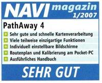
 PocketNow
Review of PathAway Professional Edition
PocketNow
Review of PathAway Professional Edition
by Mike Benten, Contributing Editor
by Russ Smith, PocketNow Contributing Editor
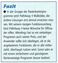
PathAway hat alle Voraussetzungen, die Klasse
der Rasterkarten-Programme zu dominieren! Das Programm
besitzt schon auf der PocketPC-Seite einen riesigen
Funktionsumfang. Track-, Routen- und Waypointverwaltung
lassen wirklich keine Wünsche offen. Die reine
Movingmap-Funktion bekommt allerdings auch der Anfänger
schnell hin. Aber so richtig kommt Pathaway erst im
Zusammenspiel mit TTQV auf dem PC zur Geltung.
Es gibt kaum ein digitales Kartenformat, DAs TTQV nicht
einlesen kann, und alle eingelesenen Karten können
erfreulicherweise MIT Übernahme der Kalibrierungsdaten
in DAs Pathaway-Format übertragen werden.
Kalibrieren ade - nur bei eingescannten Papierkarten
ist DAs natürlich auch bei PathAway/TTQV weiterhin
erforderlich. Preis: ca. 49€
PathAway has all conditions to dominate the class
of the raster map programs! The program possesses
an enormous function range on the pocket PC side.
Track, Route and Waypoint features really leave no desires
open. The pure Moving Map function also gets the
beginner working fast. But PathAway becomes even
more effective in interaction with Tourtatech-QV on
the PC. There is hardly a digital format which
TTQV cannot read in, and all maps and calibration data
can be transferred directly into the PathAway format.
Calibration aide for scanned paper maps is also a natural
fit with Pathaway/TTQV.
Great import and mapping abilities. Loaded with
features. Superb online help and documentation. Supports
Palm OS 5 and higher resolution displays. Works with
Bluetooth devices such as EMTAC. Affordably priced and
great upgrade price point when a new version is released.
Recommended. http://www.kickstartnews.com/reviews/pda/pathaway_3_gps_navmap.html
GPSComefare.com
PathAway 3: GPs+cartografia ad alto livello sul PalmOS
Italian review on GPSComefare.com.
http://www.gpscomefare.com/software/recensioni/pathaway3_palm.htmCustomer Feedback
RRobert T, Canada,
Robert T (Canada)
None of the other GPS apps I've looked at are as good as Pathaway. This spring we hiked for 6 days in the south of France and last fall for 5 days in Sweden, both times using Pathaway and maps I scanned and calibrated myself.
Tom Payer, Fairbanks Alaska,
Have used for a year now Description: You can create
your own maps, even aerial photos, and import them.
I have downloaded topos, marine charts, aerials, street
maps and sectionals. The cool thing is that you can
layer maps and switch between them. I have used this
for flight, boating and hiking.
Ding C H, Ontario
Thank-you for the fast response in attending to
whatever problem in PathAway 4 to make it the greatest
mapping software which is unmatchable in the market.
I don't think anybody dare to come out with another
software to match the functions in PathAway.
Scott Morrow, Ontario, Canada,
I have been using PathAway as my primary GPs mapping
software for well over a year. I use it for boat trips,
hiking, vacation travel, and most frequently, for geocaching.
I have spent considerable time trying and evaluating
virtually every GPs mapping package available for my
Palm PDA as well as trying out many stand-alone hand-held
GPSRs and to date, I have not found any other system
as feature-rich and specifically suited to my purposes
as PathAway on my Palm TX with a bluetooth GPs receiver.
The ability to use virtually any map of my choosing
has allowed me to load extremely detailed topographical
images of the areas in which I go hiking, canoeing and
geocaching, and I have actually had the good fortune
to visit places and see things I would have missed completely
if not for my use of PathAway.
Technical support from MuskokaTech for this product
has been second to none with new features and problem
solutions being made available on a regular basis via
the support website. The personal service resulting
from the ability to speak one-on-one with the company
founder is virtually unheard of in this day and age,
and is one of the most personally endearing and important
aspects of PathAway and MuskokaTech. As a software developer
myself, having the ability to communicate technical
issues directly with the person who is the most knowledgeable
about the product is unquestionably one of it's strongest
assets and helps to ensure my loyalty and continued
support for PathAway. Keep up the good work!
PathAway v4xx on an iPAQ HW Pocket PC machine has
proved extremely versatile.
The in-built GPs receiver of the iPAQ is seamlessly
utilized by PathAway. The 240x240 square screen (bane
of many programmers) is similarly utilized, with a very
good screen resolution.
Considering the price of the program, backup/upgrading
and response to customer concerns are very good.
From my perspective, the main value of PathAway lies
in its ability to utilize calibrated pixel maps.
Although the quality of the original pixel map has to
be chosen carefully, zoomed resolution is excellent
to perhaps 10m or less "on the ground".
My main use for PathAway has been in geological mapping.
Excellent topographical pixel maps of Australia are
cheaply available from a Govt agency and once calibrated
(very easily done), using PathAway to locate the features
being mapped is a simple, seamless task. Most efficient
and cost-effective.
Perry Curling-Hope on PocketGear
This is a raster (bitmap) based mapping system which
cleverly overcomes some of the inherent limitations
in such systems when compared with 'professional' vector
based mapping. Vector maps occupy less memory and are
scalable virtually without limit, but require expensive,
specialized software and considerable technical skill
to produce and manipulate successfully.
Pathaway overcomes the zoom limitation by allowing automatic
switching between a large map of low resolution to a
smaller map of higher resolution lying within the coordinates
of the larger map This can occur automatically when
the GPs position enters the parameters of the smaller
map, or can be switched manually.
The system is feature rich, all of which work very
well.
Icon and tracking are vector based, extending the capabilities
of this small system to an astonishing degree!
The GPs to PC screen fix is exceptionally accurate,
the best I have encountered so far.
All in all, an outstanding application for the Pocket
PC.
by Darrin Hatch on PocketGear
This software is great! I love how compatible
it is with my Audiovox VX6700! I use it for everything:
Hiking, Camping, Traveling, etc. Highly recommended!
by David Ulan on PalmGear
I'm using Pathaway on my Garmin iQue 3600 for
work in the oil field as well as 4x4 trips. I've been
using the map sets that came with my SoftMap Technologies
mapping programs, Canada Topo250 and Alberta Topo50.
Using these programs it is very easy to load maps
into my iQue and use them with Pathway.
by Marco on PalmGear
This is a simple to use, but unequaled powerful software.
I used it so far on Tungsten E running on PalmOS 5.
The performance at a 8bit color depth is just enjoyable.
By Nadim on PalmGear
I've had this program for over a month now, and have
scanned in really detailed flying charts. A 4Mb image
synchs in a blink of the eye. The sheer no. of features
the program has to offer is amazing. I would recommend
it to people wishing to use it for flying.
By Gregor, Germany
To the creator(s) of PathAway:
My congratulation for this excellent engineering
product.
I tried the demo version and found:
a.) functions (and details) are very helpful and reasonable
selected (for sportive/leisure activities)
b.) operation is intuitive.
c.) it's very stable and predictive.
By Anthony on PalmGear
PathAway is the single best program for PalmOS.
I'm using it with a Tungsten T-2, Emtac Trine bluetooth
GPs, and ETopo digital maps. It is fast and incredibly
easy to use, and it does everything you want to do when
going out on the land.
I use it for hiking, fishing and hunting. I also use
it for geocaching, and for data collection to create
my own maps of local trails.
The on-map navigation is by far the best of any software
I've tried -- many times better than Fugawi. Zooming,
tiling, and layering maps works amazingly well.
Waypoints, routes and tracks are all good. The customizable
navigation views are a really great feature.
Nothing else even comes close for the Palm. Try this
one first -- you won't be disappointed.
By Lauren Glenn on PalmGear
I've been looking for a GPs program that can tell me
how far I rode, walked, drove, etc. as well as tell
me where I currently am. Before this program, I used
2 programs and neither one did both tasks like this
program did. It not only tells you how far you've traveled,
but it will show you the route you took and save it
for later use. It makes nice use of the Hi-Res 320x320
Zire 71 screen. If you're approaching a WayPoint, it
will not only highlight it for you, it tells you how
far away it is (which is great when walking or riding).
Ivona Manitius, Quebec, Canada.
Version 3 promises to be an excellent software. Technical
support is excellent. I started using version 2 few
month ago and I liked what it how it was performing
on palm m515. New version (3) will be even more fun
to play with...
(Summary of PathAway 3 Presentation to PalmClub.nl)
People (myself included) were really impressed with:
- the High Res+ view on the Clie NX
- the zoom function
- the wider lines of the routes
These additions surely make PathAway THE program to
have for the "Moving Map" program fans.
By Tony Nilsson, Sweden
(again!)
Thanks for making the world's greatest Palm application
(over and over again!).
mescaler, Mexico City, Mexico.
Excellent Software. I Started using a very early version
of Pathaway, with my palm m500, and purchased the license,
for every problem I've always get an answer from tech
support, now I'm using it with a Tungsten and it just
works better and better. It's very useful especially
for the places where no maps are available (Mexico City).
Dan Baker, Australia
Pathaway is 'The' GPs program for the Palm, I
am running it on a Clie N760C and the display of Pathaway
is truly brilliant! I would like to say that this
program blows the competition away! There is more
'stuff' on here than I ever knew I could need! :)
by Mauricio Taslik (posted
on PalmGear)
Version 2.0 is really excellent. Most of what
I was missing in version 1.2 is now implemented: proximity
alerts, extensive tracking parameter configuration (track
bias), improved GPs reception feedback (although I'd
like to see a sky chart and some kind of warm start
for Rand McNally Streetfinder), and enhanced map handling.
General arrangement of data on the Palm display is neat
and functional with its configurable dashboard.
By Tony Nilsson, Sweden
The number of useful Palm/GPs software available
is now: 1
I've been testing quite a few different GPs Navigation
Software for the Palm, but PathAway is totally outstanding...
The customer support is also beyond compare... My e-mail
message was read, the problem was diagnosed and an ETA
of the next version was sent to me in less than 4000
seconds.
Eric Devoe (posted on PalmGear)
Nice piece of software. This is just what I was
looking for. Great companion for my GPs unit even without
the maps. Runs smoothly and flawlessly on my m505. Registering
it was a no brainer - well worth the price.
by Troy Conley
PathAway works excellent. I have been using the
PathAway software for Geocaching and the coordinates
are right on the mark everytime. I have been recommending
it to everyone that I know that has a PalmPilot with
a GPS attachment. Top of the line in my book.
Thanks, Troy PalmTroy
by Michael Compagnino
I purchased a Street Finder from Rand Mcnally for my
Palm Vx, that was the easy part... I live in Australia
so the USA maps that came with my GPS were no good to
me. PathAway solved this problem. I now can scan my
maps or download them and away I go. For all you Aussie's
looking for an inexpensive way of mapping your travel
this is it!!
by Corrado Conforti (posted
on PalmGear)
I downloaded it, installed on my palmIII + RandMcNally
Streetfinder GPS, and... I Loved it!! My problem was
to find accurate maps of strange locations, not covered
by TomTom RoutePlanner or other software. Now, I can
use Microsoft MapPoint or other PC mapping software
to select the zone, with the desired details. Then capture
the screen, import in PathAway with the mapping tools,
and go!
Yes, now I really FOUND my killer application for
Palm! A must have, for GPS-addicted guys. See http://www.dauphins.com/gps/gps.html.
by Marc Werner, Germany (posted
on PalmGear)
This is an excellent piece of software. I tried
it extensively on my Palm IIIx with RandMcNally GPS.
Everything works fine. Importing scanned or digital
maps using the Windows tool is easy, defining routes
on the Palm just by tapping on the map with the stylus
is very efficient. For my cycling tours, tracking was
accurate and the 4 different screen views (which can
be easily accessed by pressing a hard button) provide
all information you want (e.g. position, direction,
elevation, current/avg/max speed trip distance, ETA,
predefined points of interest in the vicinity). Management
of routes and tracks is well implemented. I contacted
the developers with some suggestions for future releases
(e.g. import/export of tracks). They answered the same
day saying they are working on it. Considering that
this is the first version of the program and that it
is already superior to similar products, the
rating is five stars.
If you'd like to comment about our products please fill in the Feedback form